


NWS confirms 4th tornado touchdown
Van Wert independent/EMA information
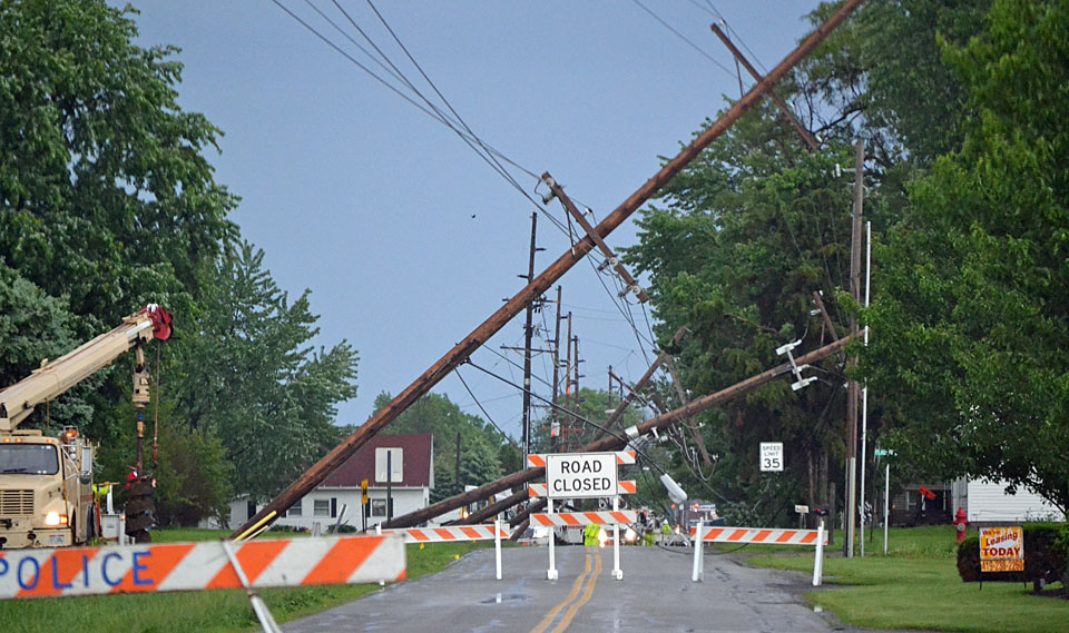
And that makes it four. The National Weather Service at Northern Indiana has confirmed that a tornado with EF-0 damage struck on the north side of the Van Wert on Wednesday afternoon, making it the fourth twister touchdown confirmed this year. The tornado’s path was two-tenths of a mile long and 40 yards wide, according to Van Wert County Emergency Management Director Rick McCoy.
EMA and witness reports state the tornado was only on the ground along Kear Road for just a number of seconds, but damaged six high-tension power poles and lines and knocked out power to nearly 1,000 customers. Power was restored to AEP customers, including affected industries, by 6 a.m. Thursday. There was also some light damage to several trees and an apartment complex along Kear Road.
This is the second tornado to hit Van Wert County this week, after the National Weather Service personnel confirmed an EF-1 tornado Monday south of Ohio City. McCoy it is still very early in the severe weather season, so four confirmed tornadoes is a fairly high number.
According to local EMA reports, the county had already been placed under a tornado watch and McCoy was tracking storm development in Indiana when the Wednesday tornado hit in the county. The EMA director the 3:27 p.m. storm cell popped up unexpectedly before the strong storms actually hit later in the afternoon.
“This cell gave no indications of producing anything and suddenly produced a rotating wall cloud and the tornado dropped out and struck,” McCoy said. “Unfortunately I was not able to put a weather statement out on the storm or activate sirens because it happened so quickly.”
McCoy said the suddenness of the storm is why people should always monitor weather conditions closely — particularly on a day when severe weather is expected — and they should be ready to act quickly if a storm becomes severe without advance warning.
McCoy said the next round of severe weather on Wednesday came at 4:33 p.m. when the National Weather Service issued a tornado warning for the western half of Van Wert County. Radar was indicating a severe thunderstorm with strong rotation in Adams County, Ind., that was moving northeast at 35 mph.
Storm spotters were already in place for the storm and were watching skies to the southwest as the severe cell approached. McCoy also had direct radio contact with area school bus drivers informing them of the possibility of a tornado heading into the county. Bus drivers then took emergency precautions by stopping buses and taking students into local homes.
McCoy commended county school district officials and bus drivers for staying informed on the storms and making good safety decisions for local children. The EMA director said he had previously contacted the schools, which were in class an extra hour because of a three-hour school delay earlier in the morning for dense fog. He advised school officials that storms were tracking northeast into Fort Wayne, Ind., but the timing of storms would allow buses to complete their routes before the storms reached Van Wert County.
McCoy said the Adams County storm suddenly made a right turn and headed directly east towards Van Wert County and buses then had to take emergency precautions.
The tornado warning was eventually extended for the eastern half of Van Wert County at 5 p.m. and sirens were sounded and warning statements issued.
McCoy said no additional damage was reported, but did state that several “gust”-nadoes were observed on Ohio 81 in the eastern part of the county and also one south of Venedocia. A gust-nado, which looks like a tornado and has strong winds rotating upwards from the ground, unlike tornado, which comes out of a cloud base. Gust-nadoes are on the leading edge of a fast moving storm and are capable of producing damage similar to tornadoes.
Wednesday’s storms, which continued through the night, not only included hail up to ping-pong ball size and strong winds, but also torrential rains that soaked into the already saturated ground across the county.
McCoy said 2.26 inches of rain fell Wednesday afternoon and evening in Van Wert, bringing rainfall totals for the month in the city to 6.73 inches. Other areas of the county have now received between 8 and 9 inches during a month where average rainfall is 3.75 inches.
Meanwhile, forecasters are finally calling for a break in the storms, with less than a 50 percent chance of rain the next five days.
POSTED: 05/27/11 at 12:44 am. FILED UNDER: News