


Twister again hits Willshire’s Green St.
Van Wert independent/Emergency Management Agency
The National Weather Service has confirmed that a tornado struck the village of Willshire during Wednesday night’s storms.
Local Emergency Management Director Rick McCoy and meteorologists from the Wilmington National Weather Service office surveyed a tornado path on Thursday and rated the tornado damage as EF-0, with winds between 80 and 85 mph. The damage path was up to 80 yards wide and was three-quarters of a mile long.
“Overall, we were very lucky, as the damaging winds were having a tough time making it to the ground at all and a number of funnels were sighted but did not touch down,” McCoy said. “Unfortunately, it was Willshire that actually had a tornado that did come down, and even more so for the residents along Green Street, who, ironically, had all of the same homes damaged by a tornado that followed the same path in 1992.”
The tornado developed in a convective squall line of storms in Indiana and moved across Adams County, Ind., into the southern part of Van Wert County. At the time, the NWS had issued a tornado warning for Adams County and Van Wert County, after radar indicated strong rotation and a possible developing tornado near Berne, Ind. Sirens then sounded in Willshire, as they did across the county, for a possible approaching tornado.
According to the NWS, the tornado hit at around 11:27 p.m., which gave Willshire a lead time of over 10 minutes of warning and siren activation prior to the tornado hitting the village.
The damage survey indicated the tornado touched down at the Ohio/Indiana State Line, at Ohio 81, and then moved slightly southeast, damaging a number of trees along its path to the Willshire village limits.
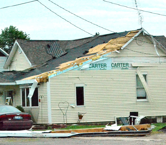
It appeared the funnel was moving up and down until it reached Williams Street, when a local resident watched it come down again and snap off the tops of two of his trees and then head down Green Street. Thirteen homes sustained damage in the two-block area before the funnel cloud lifted one final time as it crossed Ohio 49.
Damage consisted of heavy roof damage to several homes, all of the homes had shingles and/or siding ripped off, a number of the homes had windows busted out. A home at 205 Green St. also had the garage rolled off of its foundation. There were automobiles that had windows broken out and a car was crushed when a tree fell on it at a residence at 611 Ohio 49. McCoy said county storm losses would be several hundred thousand dollars.
The storm system had been predicted for three days prior to the event and it was very clear that a severe weather outbreak was going to occur, McCoy said. The big question was how many rounds of storms would move through, their timing, and if they would be wind or tornado producers.
Many media outlets were mentioning a possible derecho windstorm similar to the storm on June 29, 2012. McCoy said he was more concerned with the tornado threat — and isolated bow-echo, wind-producing storms — than he was for a derecho event.
The EMA director said that, even though the atmosphere was perfect for explosive rapid storm development, the available energy was only half of what it was when it produced the widespread derecho damage last year.
McCoy said he received a number of phone calls from area ball coaches prior to the storms and he was recommending canceling practices or games, since it was very evident that, as storms developed, they would pop out of a clear sky and go severe and possibly create tornadoes within a 10-minute time frame.
The EMA director said he felt that wasn’t enough time to get kids and parents to safety if something happened and he wanted to play it safe.
“Fortunately for our area, the first round of storms expected around 7 p.m. stayed north of our area and produced some significant wind and tornado damage in a number of counties across northeast Indiana and into northwest Ohio,” McCoy noted. “It wasn’t until about 10:30 that the entire storm complex started moving southeast towards our area.”
Shortly after 11 Wednesday night, thunderstorms moving across Adams County in Indiana began showing tornado characteristics and the NWS issued a tornado warning that also included Van Wert County. Spotters were already out at the time and sirens were activated and special weather statements given by McCoy to take shelter, giving residents on the west side of the county at least a 10-minute lead time to seek shelter.
As storms moved in, funnel clouds were observed east of Wren and Willshire, west of Ohio City, over Convoy and near Middle Point. A funnel was also spotted over Industrial Drive in Van Wert after the tornado warning had expired. That sighting prompted McCoy to continue sounding sirens in Van Wert for a longer period in case a tornado touched down.
POSTED: 06/14/13 at 5:59 am. FILED UNDER: News