


NWS: No tornado touchdown on Wed.
Van Wert County EMA information
On Thursday afternoon, Van Wert Emergency Management Director Rick McCoy met with several officials from the National Weather Service Office in North Webster, Indiana, to conduct a complete damage survey from Wednesday afternoon’s storms.
What was originally thought to be a 1½-mile path turned out to be a 6-mile path of damage, affecting mainly corn and soybean fields. Several barns in the path of the storm also sustained damage.
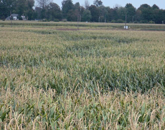
The storm’s path began in a field west of Morgan Road and moved northeast across State Road and continued just west of Delphos and ended near U.S. 30 and Ohio 66. In addition to damage reported Wednesday, Chad Overholt on Middle Point-Wetzel Road reported minor damage at his property from the strong winds and a number of trees were discovered snapped north of State Road in a wooded grove west of Middle Point-Wetzel Road.
The National Weather Service will be preparing its report and issuing a later statement but it appears from preliminary reports that the damage was caused from a combination of microburst winds with embedded gustnadoes.
The microburst winds were caused by the storm pulsing and pushing intense winds towards the ground and, at the same time with its forward movement, was causing gustnadoes to quickly spin up and add to the damage.
There were no indications from the preliminary survey that a tornado was actually present during the event, McCoy said, noting that a report will be issued once National Weather Service officials have reviewed all of their radar data and findings.
POSTED: 09/12/14 at 7:49 am. FILED UNDER: News