


Paulding County started out more square
Editor’s note: This is one of a series of articles related to the 200th anniversary of Paulding County, being celebrated in 2020.
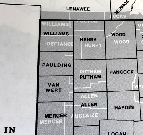
JANE NICE/for the VW independent
PAULDING — Have you ever wondered when viewing a map of Paulding County why it looks like a cake with a slice cut out of its northeast corner?
It did not start that way. In 1820, when Paulding County was formed, it was surveyed into 12 townships in three rows of four neatly and nearly equally sized square portions. The new townships were not yet labeled with the familiar names we know today, such as Crane, Carryall, and Brown. Those names would come later after settlers moved into the county.
Instead, the townships were numbered, based off the longitude line to the south and latitude line to the west. The “bottom row” of the county was labeled Township 1 North — that is, north of that longitude line. The townships that we today call Benton, Blue Creek, Latty, and Washington form the bottom grid of Paulding County, or “Row 1” of the Paulding County “cake.”
Township 2 North, or the middle row of the Paulding County “cake”, consists of Harrison, Paulding, Jackson, and Brown townships. These southern two rows of Paulding County have maintained their same boundaries, for the most part, for the past 200 years.
Paulding County’s northernmost townships — today’s Carryall, Crane, Emerald, and Auglaize — were laid out in the same manner at that time, nice and square, in a row of four, but were altered in shape 25 years later. In order to understand how Paulding County lost a slice of its “cake,” people need to look beyond the map.
When the surveys were made around 1820, there was no Defiance County. The northern border of Paulding County shared the southern border of Williams County, and Williams County was a larger sized “cake” than Paulding County. Where Paulding County consisted of three rows of townships, Williams County had more, beginning with Township 4 North and running up to the Michigan state line.
At that time, Williams County was, like Paulding County, sparsely populated and under a canopy of timber largely within the undrained Great Black Swamp. According to The History of the Maumee Valley, 1872, the first federal census, which was taken in 1820, listed a population of 387 for the Williams County territory consisting of Williams, Paulding, part of Henry, and what is now Defiance counties.
From 1820-1824, both Williams and Paulding counties were attached to Wood County for governmental purposes. For that reason, Paulding County records from that period are entwined with Wood County’s. Then in 1824, Williams County was organized, and Paulding County, as well as Henry and Putnam, were then attached to Williams County for civil purposes. After that date, Williams County recorded transactions for Paulding County for 15 more years.
Although the county of Defiance did not yet exist in the 1820s, the town did. Defiance was situated at the confluence of the Maumee and Auglaize rivers. Because waterways were the main form of transportation then, Defiance was the nucleus of activity of its home county, Williams, and it was where its official business was conducted.
However, the town of Defiance was located in the southeast corner of what was then Williams County, placing it too far from many of the county’s potential settlements. Defiance’s lack of centrality became even more of an issue in 1836 after the border war between Ohio and Michigan was settled and about 150 square miles were added to northern Williams County, stretching its border even more northward.
In the mid to late 1830s, speculators who anticipated the construction of the Wabash & Erie and Miami & Erie canals in northwest Ohio drove land sales in the Great Black Swamp. Reasonable land prices also attracted settlers to the area. In Paulding County, New Rochester, which was situated on the south bank of the Maumee River, was platted in 1835. It was the first village in the county and would become the county seat four years later when Paulding County was organized in 1839.
It is strange to think now that for a brief period of time in the late 1830s and early 1840s, the county seat of Paulding in New Rochester existed just a few miles away from the county seat of Williams in Defiance, all along the Maumee River.
In the mid-1840s, land speculators in Williams County began agitating the question of moving its county seat away from Defiance and more in the middle of the county. Despite a large number of villages being platted in Williams County by then and several aspiring to be its county seat, Bryan was chosen. According to The History of the Maumee Valley, 1872, Bryan was then “a native forest of immense trees” and “not an inhabited dwelling” existed there. (In a later Bicentennial article we will explore how Paulding became the seat of Paulding County under similar circumstances.)
In contrast, the town of Defiance was an older, well-established community with manufacturing enterprises poised on the Miami & Erie Canal, which opened the door of commerce from Ohio to the Great Lakes and beyond, to the ports of the Atlantic Ocean and Europe. Defiance’s dissatisfaction with the move of the county seat away from their town led to a petition being drawn up in an effort to secure a new county.
In order for that to happen, the proposed Defiance County would need to take property from a few of its neighbors. One can imagine that this was not a popular idea with the surrounding counties.
The petition calling for the establishment of Defiance County was circulated in Auglaize Township, Paulding County, in December 1844. It proposed that Williams County cede Townships 4 and 5 North (the two rows north of Paulding County, numbering eight townships total) and that Henry County forfeit its four westernmost townships for the cause of the new Defiance County.
On the signature page of the Auglaize Township petition is written: “We the undersigned feel willing and think that it would accommodate a large portion of the citizens of Williams and Henry, but are not willing to have any part of Paulding County to make said new county.”
Under that are five signatures: W.K. Daggett, F. Lyon, and three others that are crossed out, making them illegible.
After a short struggle, the bill to establish Defiance County, with the town of Defiance as its county seat, was taken to the Ohio State Legislature and passed by 12 votes in the House and two votes in the Senate on March 4, 1845.
The sentiment that the Auglaize Township men had communicated on the petition had made no difference. The new county of Defiance was formed from the proposed eight southernmost townships in Williams County, three townships in Henry County, and the northern half of Auglaize Township in Paulding County, comprising Sections 1-18. As a consolation, Auglaize Township was awarded the bordering four sections of Emerald Township, making Paulding County no longer symmetrical. It is as if Defiance County reached over and took a piece of Paulding County’s “cake.”
Next time: Rivers and Creeks in Paulding County.
More information on the bicentennial can be found on Facebook at www.facebook.com/PauldingCounty200.
POSTED: 03/25/20 at 7:15 am. FILED UNDER: News