


Miami & Erie Canal brings people to area
Editor’s note: This is one of a series of articles on Paulding County’s Bicentennial celebration this year.
JANE NICE/for the Van Wert independent
PAULDING — Those who can trace their Paulding County family history to the mid-1800s would find their roots are likely in the canals — either in their construction or the early settlements that dotted the routes.
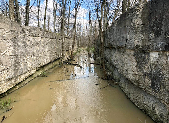
Originally known as the “Miami Extension Canal” because it extended the route built between Cincinnati and Dayton, the Miami & Erie Canal opened from Dayton to Junction in 1845, cutting a north and south path in eastern Paulding County through Auglaize, Brown and Washington townships.
More than a dozen small towns and ports were established on the canal’s course, and an important part of the Great Black Swamp’s history — the clearing of the great forests — rests on these now defunct waterways that hauled timber, its biggest natural resource, away to other markets.
Imagine climbing aboard a packet boat in the mid-1800s where the Wabash & Erie Canal meets the Miami & Erie in northeastern Paulding County. The canal era is booming and you are along for the ride. Your boat will be pulled along by rope attached to horses or mules that walk along a towpath running parallel to the canal at an average speed of four miles an hour, so as not to damage the canal’s banks.
Being the point where the two canals meet, Junction is bustling. Daily packet lines run on both canals, and many passengers are transferred here. Two or three hotels, three or four large dry goods or grocery stores, and about half a dozen saloons, as well as a brewery and a distillery serve the public here.
Junction’s wharves are lined with canal boats loading and unloading grain and freight. Toll collector James G. Haley’s office is near the port. Three large grain warehouses and a gristmill help manage local commodities, and William K. Daggett operates a sawmill a mile north of town with power furnished by the canal’s water.
Wave good-bye to the biggest port in the county and head south on the shallow waters. The next burg, just one and a half miles south of Junction, is Germantown. A stone aqueduct is located near the site of this settlement, whose glory days were brief, and was a likely example of canal worker Fred Myers’ recollections in a 1922 interview about how most of the towns along the canal were small, “but all were there when it came to noise and furnishing amusement and pleasure for the boatman and passengers alike.”
Slow down and experience Lock 21 in Brown Township and the thrill of the water being raised or lowered by the lockkeeper who manages the gates so that the boat can continue its journey. Greet locals standing on the banks who have come to watch this interesting process.
As you head into Oquanoxa’s Reserve, be sure to peer into the dense forest to look for Indians. It is said that some could still be spotted in Paulding County during the canal era. Also watch for people fishing and swimming in the canal, as many use the waters for recreation.
Next, you will pass near Charloe, a village picturesquely situated between the canal and the Auglaize River. Canal activities are regularly watched in this populated area when Charloe is the county seat, with a brick courthouse, a hotel and stores, and a population of 400-500.
Bystanders are entertained by the passing of vessels such as the Arabella, the Polar Star, the St. Andrews, the Vettie Cook, the Dreadnot, and the Ulazeppa. When two boats meet on the waterway, protocol is for them both to slow to two miles per hour to safely pass.
About a mile south of Charloe sits Canalport. This village is more of a “paper town,” plotted for home lots and buildings that never came. It does, however, serve an important role on the canal route besides being an export spot for timber. Between 1858-1868 large blocks of magnesium limestone are cut into building blocks at the Noble Stone Quarry and carried to the canal by a half-mile long tramway.
Canalport was commonly called “Exchange Bridge” or “Change Bridge.” Up to this point on your journey the towpath has been on your right, but here the mules cross the canal on a bridge and the towpath will be on your left for the remainder of your journey. Near the canal, a large barn houses rested mules and horses ready to be exchanged and take a turn towing the boats.
Before you come to Melrose, you will pass one of the earliest towns established on the canal. St. Andrews was founded in 1850, but the town could not compete with Melrose to its south, and will be abandoned by 1881.
Although it is laid out in 1854, Melrose will not become much of a town until the railroad comes through in 1881. Even earlier, this dock served as a supply spot for the canal builders. As you pass, watch for massive timbers banked on its shore, waiting to be floated in the canal to ports in Toledo and beyond.
On the waterway, be on the lookout for the canal packet Willie, which regularly carries travelers from Melrose to Defiance on Mondays, Wednesdays, and Fridays, and to Delphos on Tuesdays, Thursdays, and Saturdays.
The last port on the Miami & Erie in Brown Township is Newburgh, which is spelled a variety of ways, but it does not matter. Most refer to the town as “Royal Oak” after A.L. Darling, who came from New York with a stock of supplies to start a grocery store, crudely wrote “Royal Oak Grocery” with a piece of charcoal on a board from a box and hung it on an oak tree outside of his cabin, where he sold groceries out of the front room. Darling marries Sarah Hoover in 1860, dies two years later in the Civil War, and is buried in the Little Auglaize Cemetery.
View a beautiful stone aqueduct near Royal Oak, a busy town with a school, church, two stores, a post office, a hotel and a wagon shop. It is also a banking point for timber and a shipping point for lumber, staves, cordwood and hoop poles.
Wave at Captain Gleason if you pass him. His steam packet carries passengers and light freight from Royal Oak to Defiance and Delphos at speeds of up to six miles per hour. Captain Gleason is known for his punctual schedule, and once left his own wife in Defiance when she had not returned to the dock at the appointed hour after a shopping expedition.
Drift out of Brown and into Washington Township, and pass Murat, an early canal town that is platted in 1853 with 44 lots on each side of the canal. The “Knox” School is located in Murat, as well as a store and a sawmill. Admire the bridge here that is so high it allows boats to travel beneath it without having to be opened, as well as the wider waterway, which serves as a canal boat turnaround. Much timber leaves the banks of Murat.
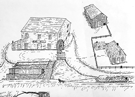
About a mile further on the waterway you will encounter the bustling village of Timberville, which is more commonly known as “Hipp’s Lock.” In 1863 John Hipp established a store and a gristmill, and the few settlers who live for miles around come to Hipp’s Mill to have their cornmeal ground. Two stores, a hotel, a blacksmith shop, a tavern and a post office serve settlers and travelers alike at this location.
Much stave timber, cord and bolt wood leaves this canal port, as well as massive ship timber cut by French Canadian woodsmen and exported to make boat masts in Europe, or ships built for use by the North in the Civil War.
Travel south through Doylestown, named for Samuel Doyle Sr., who operates a packet line that carries mail from Cincinnati to Toledo, and owns 240 acres west of the canal. According to The History of the Maumee Valley, 1872, Doyle and a partner were the first to establish regular packet lines on the canals. Knapp writes, “Samuel Doyle was the first to experiment with steam on the Miami Canal, having built in 1845, the propeller ship Niagara at a cost of $10,000 … and proved a failure financially.”
Past Doylestown is a log and supply depot for the canal crews, that will later become the village of Mandale. Next, in the southwestern corner of Paulding County, less than a mile from the Putnam County line, is the village of Hamer. Plotted in 1848 with 37 lots on three streets, Hamer is Paulding County’s southernmost canal town. It has a school, a church, a sawmill, a general store, a freight warehouse, a blacksmith shop, and a post office.
Next time: The Wabash & Erie Canal and the Reservoir War.
More information on the bicentennial can be found on Facebook at www.facebook.com/PauldingCounty200.
POSTED: 04/26/20 at 10:49 pm. FILED UNDER: News