


Spring Severe Weather Awareness Week tips
SCOTT TRUXELL/independent editor
The National Weather Service has designated this week as Ohio Spring Severe Weather Awareness Week to promote severe weather awareness and preparedness, including reminders and safety tips.
Severe thunderstorms produce a variety of weather hazards including tornadoes, large hail, damaging straight line winds, flooding and lightning. Severe thunderstorms producing damaging winds in excess of 60 miles per hours and large hail can be a threat to life and property. Damaging straight line winds are much more common than tornadoes and can be just as deadly.
Those caught outdoors during a severe thunderstorm are particularly vulnerable. Boaters and campers should be especially alert to the potential of severe storms. High winds associated with severe thunderstorms can strike suddenly and can easily capsize boats and put campers at risk due to falling trees.
At any given moment, there are 1,800 thunderstorms in progress somewhere on earth. In the United States, there are an estimated 25 million cloud-to-ground lightning flashes each year. The National Weather Service said while lightning can be fascinating to watch, it is also extremely dangerous.
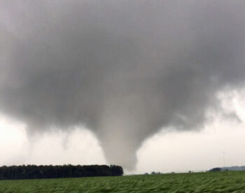
Tornadoes are violently rotating columns of air that extend from a thunderstorm to the ground. Tornadoes can destroy buildings, flip cars, and create deadly flying debris. While Ohio’s peak tornado season typically runs from April to July, they can happen anytime and anywhere and bring intense winds over 200 miles per hour.
32 tornadoes were confirmed in Ohio in 2021, including two on August 11, one near Middle Point and the other near Delphos.
If the National Weather Service issues a tornado or severe weather warning, the following safety steps are strongly recommended:
- Go to NOAA Weather Radio and local radio or official social media accounts for updated emergency information.
- Follow the instructions of state and officials.
- Go to a safe shelter immediately, such as a safe room, basement, storm cellar or a small interior room on the lowest level of a sturdy building.
- Stay away from windows, doors, and outside walls.
- Do not go under an overpass or bridge.
- Watch out for flying debris that can cause injury or death.
- Use your arms to protect your head and neck.
Due to increased potential for severe weather, the statewide outdoor warning siren activation scheduled for 9:50 a.m. this morning has been canceled.
Flooding results in more weather related fatalities than any other thunderstorm related hazard, because many of the deaths occur in automobiles when driven through flooded roads as they are swept downstream.
Water weighs 62.4 pounds per cubic foot and typically flows downstream at 6-12 miles per hour. When a vehicle stalls in the water, the water’s momentum is transferred to the car. For each foot the water rises, 500 lbs. of lateral force is applied to the automobile, but the biggest factor is buoyancy.
For each foot the water rises up the side of the car, the car displaces 1500 lbs. of water. In effect, the automobile weighs 1500 lbs. less for each foot the water rises. Two feet of water will carry away most automobiles, leading to the National Weather Service slogan “Turn Around, Don’t Drown.”
POSTED: 03/23/22 at 3:39 am. FILED UNDER: News