


Strong storm causes damage in Convoy
SCOTT TRUXELL/independent editor
CONVOY — Was it a late February tornado or just strong winds? There’s no concrete answer yet but either way, a powerful storm left a trail of damage in the Convoy area Monday afternoon.
According to Van Wert County EMA Director Rick McCoy, his office received a call at 3 p.m. from Tully Harrison Rd. two miles southwest of Convoy reporting very strong winds, very heavy rain and low visibility. At the time, a tornado watch was in effect for much of the area, including Van Wert County.
Within the span of six minutes, a 57 mile per hour wind gust was recorded at the Convoy Fire Department, then a 911 call was received about snapped power lines from a large pole/transformer on a car with three occupants inside on Convoy Rd., just west of the Convoy village limits. Another 911 call was received from an individual in a car reporting a funnel coming down but not quite touching the ground just north of U.S. 30 at Colwell Rd., northeast of Convoy.
“The driver advised he was going to video it but blinding rain then hit,” McCoy said. “EMA contacted National Weather Service North Webster with the funnel report but nothing was indicated on radar. After this point damage reports started coming in from Convoy.”
McCoy did a preliminary survey of the damaged area and interviewed several individuals involved. Ground photos were taken but no aerial photos could be snapped with the drone as rain continued fall.
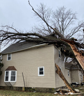
“Damage was persistent for a half mile with width a block wide,” he said. “A witness reported intense popping of his ears, a splattering of debris of 360 degrees around homes from the ground up to the rafters and barn doors blown in from the north side.”
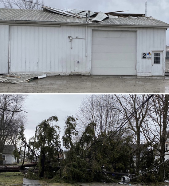
Numerous tree limbs had been twisted off and trees were snapped off to the north and northeast. A 2×6 board was driven deep into the ground and other damage included a small chicken coupe lifted airborne across driveway and dropped next to house, and a number of power poles snapped.
A witness reported seeing a large amount of heavy metal in storage bin lifted across the business lot and dropped. Many homes had heavy shingle damage and some had siding ripped off, and a tree fell on a house on Sycamore St. Damage was also reported at Mercer Landmark in Convoy. Witnesses reported hail proceeded the period when damage occurred.
Smaller tree limbs, fences and trampolines were damaged in a three block area. It was also noted that the line of the damage path lines up to the northeast outside of Convoy where the funnel was observed.
“It also lines up to the northeast where an outbuilding was destroyed at U.S. 127 and Ohio 114 in Paulding County with the debris thrown across the field to the northeast.”
McCoy estimated winds at approximately 80 miles per hour, and he said the information has been forwarded to the National Weather Service to determine if there may have been a brief spin-up of a tornado or intense winds.
POSTED: 02/27/23 at 9:47 pm. FILED UNDER: News