


Tornadoes touch down in area counties
SCOTT TRUXELL/independent editor
For the most part, Van Wert County was spared severe storms that were forecast for Tuesday afternoon and evening but it was a different story in neighboring Paulding, Mercer, and Auglaize counties.
A tornado watch was issued for most of the area but in Van Wert County, an evening storm system, at approximately 7 p.m., split north and south, leaving most of the county dry, a marked contrast to a forecast that called for showers and thunderstorms, along with heavy rain and possible hail at times on Tuesday.
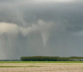
However, spotters reported a rotating wall cloud near the Van Wert/Paulding County line. It was visible from the Convoy area and just outside the village of Scott and eventually spawned a funnel cloud that touched down just outside of Melrose. Scanner traffic indicated the unconfirmed tornado damaged a house. There were no reports of injuries.
The National Weather Service issued tornado warnings for Allen County, Indiana, Paulding County and in Mercer and Auglaize counties, where a separate unconfirmed tornado touched down in the Fort Recovery area and reportedly moved on to the Celina and Coldwater areas, causing unknown damage. If confirmed to be a tornado, it would be the second one in Mercer County in less than a week. An EF-U (unclassified) landspout tornado touched down near Rockford on Saturday.
The National Weather Service is expected to gather information to confirm the tornadoes and to give them a rating on the Enhanced Fujita (EF) scale.
POSTED: 05/08/24 at 3:31 am. FILED UNDER: News