


Tornado confirmed in Melrose area
SCOTT TRUXELL/independent editor
PAULDING COUNTY — The National Weather Service has confirmed that a tornado touched down in Paulding County Tuesday evening. Evidence came through a survey of damage, along with photos and videos.
The EF-1 tornado was confirmed two miles west-southwest of Melose. It touched down at 8:11 p.m. and was on the ground for three minutes, traveling 3.2 miles with a maximum path width of 300 yards and maximum wind speeds of 105 miles per hour. It lifted one mile west-southwest of Oakwood. There were no fatalities and no reports of injuries.
NWS noted several reports of funnel clouds and a touchdown were received from near Latty east to south of Melrose and west of Oakwood. The most extensive damage occurred north of Township Road 82, along Township Road 151 where over a dozen structures were impacted. An unanchored home was moved 18 feet off its foundation into the west side of a barn.
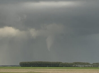
Trained spotters first reported a rotating wall cloud near the Van Wert/Paulding County line. It was visible from the Convoy area and just outside the village of Scott and it eventually spawned a funnel cloud that touched down. At the time, the area was under a tornado watch.
Outside of the wall cloud near Convoy and Scott, Van Wert County was spared severe storms, with most of the county remaining dry throughout the evening event.
To the south, the National Weather Service Wilmington confirmed a tornado that touched down in Mercer County and traveled into Auglaize County. Fort Recovery and New Knoxville were among the areas hit, but the NWS is working to finalize details. Another Mercer County tornado, west of Coldwater, was confirmed as well, along with another tornado in Darke County, near/in Greenville.
POSTED: 05/09/24 at 3:38 am. FILED UNDER: News