


NWS updates Wednesday storm info
VW independent staff/submitted information
More information has been released about a tornado that touched down just outside of Van Wert on Wednesday night, plus a second tornado that did substantial damage in Putnam County.
After meeting with Van Wert County EMA Director Rick McCoy on Thursday, meteorologists from the National Weather Service Northern Indiana traced the first tornado, which first touched down just on the outside of the City of Van Wert at the intersection of Mendon Road and Hospital Drive. The twister continued to the northeast along a nine mile path before crossing into Putnam County for a short distance, then dissipated.
Thursday evening, the National Weather Service rated the tornado an EF-1 twister with wind speeds of 95 miles per hour. Its maximum width was 300 yards and it was on the ground for nine minutes and traveled 12.6 miles. It was Van Wert County’s 40th recorded tornado since 1950 and the 35th since 1990.
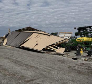
According to McCoy, numerous homes along the path had roof and siding damage along with some garages and outbuildings destroyed. There were also several barns destroyed and a couple of locations with grain bins heavily damaged. A considerable amount of trees were uprooted or snapped along the path and power lines were down in a number of locations.
McCoy said no injuries were reported in Van Wert County and that cleanup was underway across the county on Thursday. He added most power had been restored. The EMA Office reported other areas of the county had wind damage, including the Ohio City and Converse areas.
Earlier in the day, the Storm Prediction Center had been warning of severe weather and possible tornadoes across multiple states including Ohio. Local EMA tracked storms during the afternoon and evening as they moved out of Illinois into Indiana. The county had been placed under a tornado watch early in the evening and as the evening progressed, a storm producing a tornado on the north side of Indianapolis northeast to Muncie prompted McCoy to activate the countywide spotter network as the storm was heading towards Mercer and Van Wert counties.
As the line of storms moved across Adams County, the National Weather Service issued its first severe thunderstorm warning for Van Wert County at 10:19 p.m. and a second warning at 10:42 p.m. which called for damaging winds with the risk of a tornado. However, NWS did not issue a tornado warning for Van Wert County.
Once the storm was exiting the northeast portion of Van Wert County, the National Weather Service observed strong enough rotation on radar to issue a tornado warning for Paulding and Putnam counties, which produced a tornado in the Dupont area, injuring three individuals who were rolled in their mobile home. They suffered non-life threatening injuries.
According to the NWS, that tornado spun up north of the decaying Van Wert County twister, touching down in far southeast Paulding County and severely damaged a pole barn before moving into Putnam County. It destroyed several buildings there and directly hit Dupont.
At its peak, the tornado was an EF-2 twister with winds up to 120 miles per hour.
POSTED: 04/03/25 at 9:49 pm. FILED UNDER: News