


Tornado touched down outside of Van Wert
SCOTT TRUXELL/independent editor
Wednesday started with a bang and ended with one in much of Van Wert County, including a tornado just outside of Van Wert.
Strong thunderstorms moved through the county early Wednesday morning. Those storms packed heavy rain, plenty of thunder and lightning and hail. In fact, the hail led to icy road conditions in the Convoy area. At least two accidents occurred due to ice along U.S. 30. Rain continued through much of the morning and once it subsided at approximately 10:30 a.m., Van Wert County EMA Director Rick McCoy said 1.73 inches of rain had fallen in Van Wert by that point.
By late afternoon, temperatures rose into the lower 70s and humidity increased, which help fuel night time storms. A tornado watch was issued for much of Ohio during the evening hours. Tornadoes were suspected in parts of Indiana, including the Indianapolis and Muncie areas. The Muncie storm eventually moved into Mercer County then into Van Wert County, where spotters in villages throughout the county were called into duty by McCoy.
The Willshire and Wren areas were hit first, with rain and strong winds that brought down trees and limbs and caused a late night power outage. The National Weather Service Northern Indiana noted rotation in Van Wert County and said a wall cloud was spotted by a trained spotter south of Willshire.
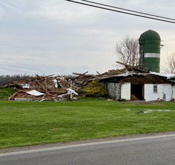
Sheets of rain blew through Van Wert, Middle Point and Delphos at approximately 11 p.m. and winds at the Van Wert County Fairgrounds were clocked at 65 miles per hour. Once that line passed through, the threat of severe weather all but ended and reports of trees down began to come into the Van Wert County Sheriff’s Office. A barn was blown down on Middle Point Rd., just east of Ohio 116. McCoy said the damage was caused by a tornado. More information, including the strength of the twister, will be released once National Weather Service surveyors check the area today. There were multiple reports of power outages in Delphos, prompting school delays on Thursday morning.
A tornado watch that had been issued by the National Weather Service Northern Indiana at approximately 8 p.m. was set to expire at 4 a.m. but it was canceled before 12:30 a.m. McCoy was surveying storm damage until 3 a.m. and is doing more today.
While the all clear was given in Van Wert County, a tornado warning was issued for parts of Paulding, Putnam, Defiance and Henry counties. Putnam County EMA Director Brian Hilvers issued an early morning statement that said lines and trees were down and big amounts of debris were noted throughout the county. He also said several buildings and homes were destroyed or damaged, with the Dupont area hit the hardest. Three injuries were reported, none non-life threatening, and he said multiple roads were closed due to storm damage. A National Weather Service has sent a damage assessment team to survey the affected area.
POSTED: 04/03/25 at 7:22 am. FILED UNDER: News