


NWS explains why twisters were unwarned
SCOTT TRUXELL/independent editor
It’s been a week since two late night tornadoes touched down in Van Wert County, both of which were unwarned twisters.
According to the National Weather Service Northern Indiana, the first tornado developed in a field east of Glenmore Rd. near Ohio City at 10:58 p.m. Wednesday, April 2. It snapped several trees then continued northeast through empty fields and crossed Ainsworth Rd. before destroying an outbuilding and lofting debris up to 400 yards away. It dissipated at 11 p.m. in a field north of Ainsworth Rd. The EF-1 tornado had a maximum width of 50 yards and maximum wind speeds of 100 miles per hour.
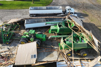
At 11:02 p.m., a tornado touched down just south of Van Wert, where a barn was destroyed on Peter Collins Rd. It continued to the northeast through open fields. Tree and shingle damage was then noted on Middle Point Rd. near the intersection of Ohio 116, where the twister leveled a barn. The National Weather Service said the tornado may have briefly skipped as it traveled northeast before causing noticeable damage on Lincoln Highway. It then caused some minor damage to a deer farm before destroying a pole barn. According to NWS, the last noticeable damage occurred just northwest of Ottoville. It was classified as an EF-1 tornado with wind speeds of 95 miles per hour, a maximum width of 300 yards and a track length of 15.6 miles. As the twister dissipated, another tornado formed just to its north and caused considerable damage in Putnam County, with Dupont hit hardest.
The National Weather Service issued a severe thunderstorm warning and a tornado watch for Van Wert County, but no tornado warnings, but a tornado warning was issued for Paulding and Putnam counties. At daybreak last Thursday, it quickly became evident the damage in Van Wert County was caused by more than a thunderstorm.
“While we did not have a tornado warning issued on the cell as it moved through Van Wert County, I will note that there were a couple separate severe thunderstorm warnings issued up to 39 minutes ahead of the first tornado occurring in the county,” said Dustin J. Norman, Warning Coordination Meteorologist for the National Weather Service Northern Indiana. “This severe thunderstorm warning included the enhanced tags of ‘70 mph’ and ‘tornado possible’ which is in excess of our base severe thunderstorm warning, which is 58 mile per hour winds or great and one inch or larger hail.”
The NWS Northern Indiana is based in Syracuse, Indiana, approximately 75 miles from Van Wert. It serves a total of 37 counties – 24 in northeast Indiana, eight in northwest Ohio, and five in southwestern Michigan. Norman indicated the distance may have been a factor in no tornado warnings being issued in Van Wert County.
“In a very favorable environment like we saw last week, these tornadoes spun up below the radar beam and would have only been more detectable if our equipment was closer to Van Wert,” he explained. “At this distance, our lowest radar beam is 5,000-6,000 feet above the ground, which causes inherent limitations. As it tightened up near the Paulding/Putnam/Van Wert borders we saw enough to prompt a tornado warning.”
“Unfortunately, there is not always a clear signature on radar and the enhanced severe thunderstorm warning supplements the uncertainty in these situations,” he added.
Fortunately, no one was injured or killed in either tornado in the county but as noted earlier, damage was significant. The National Weather Service sent employees to survey the damage and they, along with Van Wert County EMA Director Rick McCoy, spent considerable time tracking the damage. The twister near Ohio City wasn’t confirmed until later in the day on Thursday and after initially noting the other tornado was 12.6 miles in length, it was later lengthened by three miles based on storm damage and debris.
“Our ground surveys are typically done within one or two days after the event,” Norman said. “We cover a lot of ground and are often collaborating with emergency management and folks back at our office. Sometimes counties have not completed their own assessments by the time we get out there. As a result, certain data points might get missed so as that additional information comes out, we will make amendments to the track. It’s not very common, but it is a normal procedure we try to follow when the situation arises.”
The tornadoes were the 40th and 41st in Van Wert County since 1950 and the 36th and 37th since 1990, unofficially the most in Ohio.
POSTED: 04/08/25 at 8:56 pm. FILED UNDER: News