







Museum releases reprint of 1882 Paulding Co. history
VW independent staff/submitted information
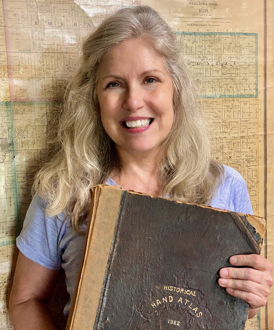
PAULDING — Melinda Krick has a heart for preserving local history and thanks to her, soon you will have the opportunity to place an important volume of Paulding County history on your bookshelf.
The Historical Hand-Atlas 1882 Illustrated and History of Paulding County, Ohio is now available for presale, with delivery in November, just in time for Christmas.
Only a few copies of the original over-sized book – printed 144 years ago – survive and the photocopied versions that are floating around are small print and difficult to read.
Published 10 years later, the 1892 Paulding County atlas is widely available, thanks to a reprint done in 1976 to honor the country’s Bicentennial. The 1882 volume contains original information that the 1892 atlas does not.
The newly printed nine by 12-inch hardcover edition is 124 pages long, and packed with local history from a century and a half ago. Along with summaries of local, township, and village histories, the book contains biographies of the leaders of the community as well as township maps and several never-before printed photographs.
So much changed locally in those 10 years. Paulding County would have been in its canal era in 1882, and on the cusp of railroad transportation. Both a north-south and an east-west railroad opened in 1882, just months after the publication of the book. Krick points out that the Reservoir War still was five years in the future when the original was printed, and the courthouse that stands today was not yet built.
“This is going to be completely new material for many people,” Krick said. “It’s exciting to think that some kid is going to pick up this book and have insight to what Paulding County was like all those years ago. Today, we take for granted what these pioneers had to endure.”
Many of the featured citizens resided alongside one of the two canals, and many of those locations are now ghost towns. The personal sketches reveal that a lot of children did not survive to adulthood and a lot of mothers did not live through childbirth. The book’s profiles include former slaves, women and a great many Civil War veterans. It also contains some history of the Indians who resided in early Paulding County.
The original 1882 atlas contained no local maps or photographs. Popular in the last quarter of the 1800s, these books were designed as global atlases containing world, United States, and Biblical histories with maps and illustrations pertaining to these larger subjects. Typically, a small section in the back was devoted to local history. That content was contracted out to historians and newspaper editors of that region, and individuals paid to have their biographies printed in them.
Local author, poet and journalist Everett A. Budd was responsible for the Paulding County histories in both the 1882 and 1892 atlases. He used some material from the 1882 book for the 1892 version, making the 1882 Atlas original source material. Budd was a Civil War veteran and early Paulding County settler. He wrote a poem about Bowman’s Rock, which sits in the Oakwood Park to this day and bears his name.
“This was maybe the first attempt at writing a county history,” Krick explained. “He had to completely compile all the information, go through handwritten records and go talk to other early settlers to gather facts about the first residents, first marriages, first schools, first churches, early industries and more. We can easily look up this information now, but there were no libraries and few newspapers here in those days. Mr. Budd pretty much had to start from scratch.”
For the reprint of the 1882 Atlas, Krick used the 1878 plat map, which is the earliest known map of Paulding County property owners. That map is widely available, but has not been printed in a book before. She painstakingly restored dozens of photos to include in the book, using a computer program rather than A.I., taking up to eight hours per image to restore. Many of the originals had been taken using glass-plate negatives in the days before film cameras were used.
“The photographs give people a taste of what it was really like in the early days,” Krick said. “The wooden buildings, plank sidewalks, dirt streets, business signs and large multi-paned windows take you back to another era. You just wonder what was in those buildings. Who worked there? What were they selling?”
She said that the pictures of the Six-Mile Reservoir make you feel like you could actually be standing on the bank and looking out over miles and miles of water with the unbroken woods in the background.
Amid this year’s buzz about America’s 250th Anniversary, talk of reprinting the 1882 Paulding County atlas and offering it to the public increased at the Paulding County History Museum. Krick felt called to be the one to take on the project.
“I’ve never done a book or anything this long, but I felt like I had the knowledge and skill to do it,” she said.
From 1998 to 2019, she was the editor of the Paulding County Progress, where she created an annual supplement, called Visions, which highlighted local history in each issue and became something that readers collected.
Most recently, Krick has been one of the researchers to obtain the Paulding Downtown Historic District designation. From that information, she created a Historic District Walking Tour brochure. She worked on the three Paulding County pictorial history books and wrote the application for the Ohio Historical Marker at New Rochester.
Pictures are her passion. Since the 1980s, Krick has collected photographs of local historic significance. Many appear in this book, as well as several from the museum’s collection. She poured many volunteer hours into the project, from planning to reformatting to adding original maps and photographs, resulting in a very accessible “new and improved” version of the original 1882 work. It was helpful to bounce ideas off of fellow volunteers at the Paulding County History Museum. She also enlisted some of them to be proofreaders.
The 1882 Atlas will be an invaluable resource for genealogists and researchers of local history. The book is available for a presale cost of $45. The 1892 Atlas can also be purchased in a bundle for a presale price of $55 for both books. Pre-sale orders are due by November 10 and can be purchased through the Paulding County History Museum. Order forms also are on the museum’s Facebook page, at the library and at West Bend Printing in Antwerp.
After that date, the regular price for the 1882 Atlas will be $50, and the two books together will be $60. All proceeds from the sale of the books go to the museum.
Krick will be among several local authors at the museum’s “Meet the Author Night” on Tuesday, November 17. The event will be open to the public and is part of the upcoming Festival of Trees celebration.
POSTED: 10/16/26 at 11:45 pm. FILED UNDER: Top Story