


Second EF-1 tornado hit near Glenmore
VW independent staff/submitted information
The National Weather Service Northern Indiana has confirmed that a second tornado from Wednesday night’s storm hit Van Wert County.
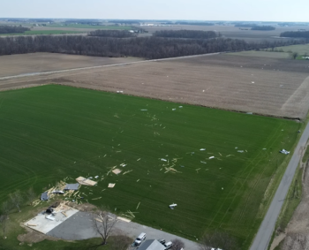
Van Wert County Emergency Management Director Rick McCoy said this afternoon that a brief EF-1 tornado with peak winds of 100 miles per hour was confirmed near Glenmore. The tornado mostly moved through open fields but did snap a few trees and completely destroyed an outbuilding on Ainsworth Road, lofting debris up to 400 yards away. National Weather Service investigators collaborated with McCoy to make the determination.
The additional tornado put Van Wert County at 41 tornadoes since 1950, No. 1 in Ohio. 36 of those tornadoes have occurred since 1990.
In addition, a survey from the path of Thursday’s initial tornado that began at Mendon Road/Middle Point Road, just outside of Van Wert up to the Putnam County line has been extended. Additional damage has been confirmed west of Mendon Road extending southwest crossing Collins Road, Peter Collins Road, Greenville Road and U.S. 127 for a total of an additional two mile damage path. According to McCoy, it was noted that more homes had minor damage with a number of trees uprooted or snapped along with one barn destroyed on U.S. 127. This puts the entire tornado path now at 14.6 miles.
NWS rated that tornado an EF-1 twister with wind speeds of 95 miles per hour. Its maximum width was 300 yards and it was on the ground for nine minutes.
Once the storm was exiting the northeast portion of Van Wert County, the National Weather Service observed strong enough rotation on radar to issue a tornado warning for Paulding and Putnam counties, which produced a tornado in the Dupont area, injuring three individuals who were rolled in their mobile home. They suffered non-life threatening injuries.
According to the NWS, that tornado spun up north of the decaying Van Wert County twister, touching down in far southeast Paulding County and severely damaged a pole barn before moving into Putnam County. It destroyed several buildings there and directly hit Dupont.
At its peak, that tornado was an EF-2 twister with winds up to 120 miles per hour.
POSTED: 04/04/25 at 4:01 pm. FILED UNDER: News