







McCoy: Time to watch out for fall storms
Emergency Management Agency information
It’s that time of year again when the severe weather season starts ramping up again in northwest Ohio. According to Van Wert County Emergency Management Director Rick McCoy, each year storms start hitting shortly after Labor Day and continue through approximately Thanksgiving.
“It’s considered the secondary tornado season for Ohio and Van Wert County has seen its share of severe weather during this time of the year”, he said.
Seven fall tornadoes have hit in Van Wert County on the following dates: September 14, 1990, east of Middle Point; October 24, 2001, just north of Delphos; September 20, 2002, just north of the Van Wert; November 10, 2002, the historic F-4 tornado that ravaged Van Wert County; October 26, 2010, two tornadoes, with one touching down west of Convoy and the second one traveling west of Scott; November 17, 2013, north of Wetzel.
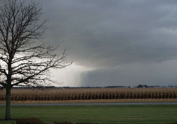
McCoy advised that the National Weather Service is advising that this Wednesday is a day that needs watching for severe weather activity across the Great Lakes and the Ohio Valley. A vigorous weather system with strong wind fields is forecast to come through the area with the potential for severe storms and damaging winds.
According to McCoy, the timing of the storms late in the day and the amount of low level wind shear will dictate how severe it may become and whether thunderstorms will rotate, which increases the chance of tornadoes.
He advised that he will be updating his Facebook page and will be issuing weather statements on the local EMA frequency 155.805, if severe weather threatens. People should also follow local statements from area media outlets and National Weather Service statements on NOAA weather radios.
The local EMA office reminds residents that the best safety precautions to take during the fall severe weather season include monitoring weather conditions if severe weather is forecast. Secondly, have a plan on how to react and safety protect oneself and one’s family if severe conditions threaten. And, lastly, understand how warning sirens are sounded in the event of a tornado warning.
There are currently outdoor warning sirens in all of the villages in Van Wert County, as well as five sirens in the city of Van Wert. McCoy noted that when a spotter observes a tornado or the National Weather Service radar indicates a tornado forming and the warning is issued, sirens will be activated for the area of the county in which the tornado is expected to travel.
As long as the sirens continue to be sounded in a particular area, the threat still exists. Warnings can come very quickly or there are times that residents are fortunate enough to have up to a 15- to 20-minute lead time before the storm hits.
McCoy reminds residents that the outdoor warning sirens are meant to alert people who are outdoors. Individuals in their homes or place of work need to rely on NOAA weather radios, media, scanners and cell phones to receive alerts.
POSTED: 09/09/14 at 7:31 am. FILED UNDER: News